
A History of a Sea and the North American Rivers Which Never Existed
At a distance, European cartographers described lakes, rivers and inland seas north of the Americas: cartographic fictions, their invisible imprint has survived time.
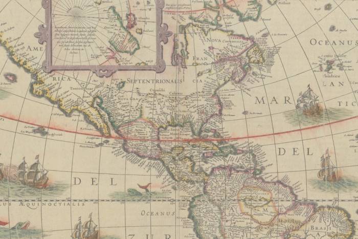
Bodies of water are always steeped in mystery and magic. The preferred haunts of ghost women, they’re home to many other monstrous and mythological beings. But lakes, rivers and seas have also been ghosts in and of themselves. Proof of this is in those which, in other times, have appeared as real on maps and navigation charts of the American continent.
In a 1708 edition of the English newspaper, The Monthly Miscellany of Memoirs for the Curious, Admiral Bartholomew de Fonte narrated a fabulous journey through North America. The navigator departed from Lima, Peru, sailed the entire Pacific, and reached the very north of the continent. Once there, he found an intricate route through bodies of water, lakes, rivers and an inland sea that allowed him to cross over to the Atlantic. It was a route which, at the time, both traders and travelers longed to find, but one which as we know, never existed.
The admiral’s chronicle is fantastically detailed. Aided by a gentle wind, he reached a lake (which he named Lake de Fonte) about 100 meters deep and in which he found enormous cod and haddock. Not only that, but the lake held numerous small islands abundant with cherry trees, strawberries and other wild berries. The surrounding land was covered in forest, bushes and moss which fed the hordes of stout moose.
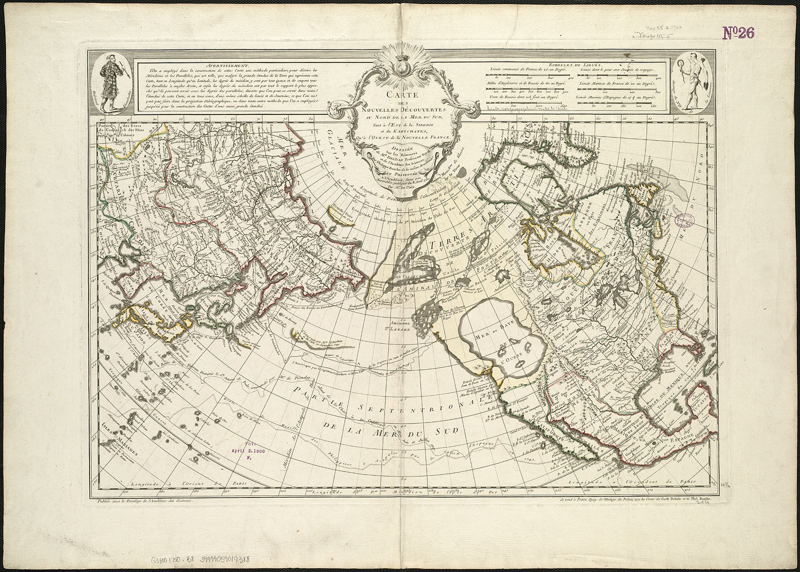
A journey of this character, and its very existence, have never been proven. Several scholars attribute the chronicle to the editor at the English newspaper. But the imaginary journey reminds us that maps, long ago, were in fact made up of ideas. In drawing the maps of North America, especially during the 18th-century, European cartographers were inspired by the stories of those who’d traveled to America or by the chronicles that fell into their hands. The lines on the maps, in fact, were drawn based on chronicles and nautical references. As it was completely impossible to verify their veracity, even the most renowned cartographers drew maps full of errors and elements which never existed. Many of these were decidedly more aspirational (often including navigable routes), or simple lies, rather than geographical realities. In de Fonte’s case, his route would have been a convenient solution for the French and English merchants of his time. Those who recorded the journey on paper, perhaps, really wanted it to have taken place.
Experts in ancient maps note that the supposed existence of an interior sea in North America had been depicted since the 16th-century. It was called Mer de la Ouest or the West Sea. It began when the Italian navigator, Giovanni de Verrazzano, spotted the bodies of water adjacent to North Carolina’s Outer Banks. He believed he was seeing another ocean – that which appeared on the maps for a while and later disappeared. The navigator, Juan de Fuca (1536-1602), meanwhile, described the West Sea as a huge inland sea. This would appear on a great number of maps and then vanished only when cartographers and explorers verified that it had never existed. The fantasy of its existence, in fact, followed the interests of the French crown in the New World. The same happened with a supposed West River, drawn on so many maps, though it had never lapped at American shores.
Seas and rivers which never existed remind us of the beautiful fiction that is cartography. It’s one which, long before there were satellites, was also an expression of something more than a mere territory. Bodies of water which never existed, like ghost islands, outlined desires, fears, and fantasies, along with the fictions of those who’d invented them, or once told of their existence.
Related Articles
When ancient rituals became religion
The emergence of religions irreversibly changed the history of humanity. It’s therefore essential to ask when and how did ancient peoples’ rituals become organized systems of thought, each with their
Seven ancient maps of the Americas
A map is not the territory. —Alfred Korzybski Maps are never merely maps. They’re human projections, metaphors in which we find both the geographical and the imaginary. The cases of ghost islands

An artist crochets a perfect skeleton and internal organs
Shanell Papp is a skilled textile and crochet artist. She spent four long months crocheting a life-size skeleton in wool. She then filled it in with the organs of the human body in an act as patient
A musical tribute to maps
A sequence of sounds, rhythms, melodies and silences: music is a most primitive art, the most essential, and the most powerful of all languages. Its capacity is not limited to the (hardly trivial)
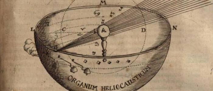
The enchantment of 17th-century optics
The sense of sight is perhaps one the imagination’s most prolific masters. That is why humankind has been fascinated and bewitched by optics and their possibilities for centuries. Like the heart, the
Would you found your own micro-nation? These eccentric examples show how easy it can be
Founding a country is, in some ways, a simple task. It is enough to manifest its existence and the motives for creating a new political entity. At least that is what has been demonstrated by the
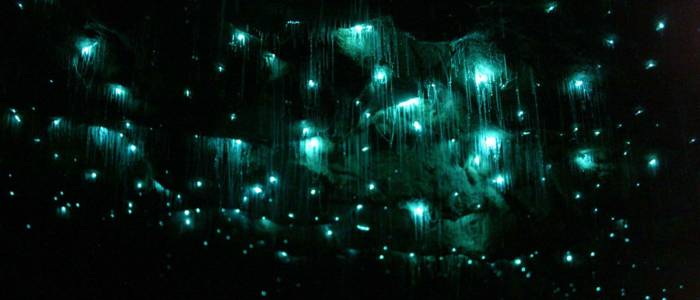
Wondrous crossings: the galaxy caves of New Zealand
Often, the most extraordinary phenomena are “jealous of themselves” ––and they happen where the human eye cannot enjoy them. However, they can be discovered, and when we do find them we experience a

Think you have strange reading habits? Wait until you've seen how Mcluhan reads
We often forget or neglect to think about the infinite circumstances that are condensed in the acts that we consider habitual. Using a fork to eat, for example, or walking down the street and being

The sky is calling us, a love letter to the cosmos (video)
We once dreamt of open sails and Open seas We once dreamt of new frontiers and New lands Are we still a brave people? We must not forget that the very stars we see nowadays are the same stars and

The sister you always wanted (but made into a crystal chandelier)
Lucas Maassen always wanted to have a sister. And after 36 years he finally procured one, except, as strange as it may sound, in the shape of a chandelier. Maassen, a Dutch designer, asked the