
The Subtle Beauty of Planned Cities
A series of satellite photographs reveals the aesthetic traces of the best-planned cities in the world.
Sometimes it’s easy to underestimate the beauty of an urban landscape; photographs, however, can often capture things often overlooked even in the spaces directly surrounding us, which reminds us that, in the end, everything is a question of perspective.
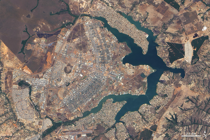
Brasilia (below), the capital of Brazil, is one of the many cities in which urban planning was considered and employed in the very beginning stages of its official opening in 1960. One of the famous facts of the city is that it was constructed in the form of a bird, symbol of Brazil’s flight towards progress.
Australia’s Canberra, constructed at the end of the 19th century while Sidney and Melbourne were both vying to be the principal metropolis of the country, was purposefully built in between the two existing cities. The project The Ideal City was designed by architect Burley Griffin in 1920 and was used as the official blueprint for Canberra. By 1927 the Australian legislative body was moved to this new city, where there were already 350,000 persons living.
Palmanova, in northwestern Italy, constructed in the heyday of the Renaissance in 1593, was especially designed to defend itself from the Ottomans. Sadly, however, nobody wanted to move to Palmanova and in time it was converted into a sort of criminal halfway house. Today the city is a national monument with a population of 5,000 persons.
El Salvador, in Chile, is a small mining town constructed after the discovery of copper in the region in 1959. The builder was the Anaconda Mining Company. Today the mine is still active and there are about 7,000 persons living in the city that was constructed to look like an ancient roman helmet.
Construction was started on Argentina’s city of La Plata to provide a capital for the province of Buenos Aires, which later took the name of the city. It was founded in 1882 and by 1884 was the first city in Latin American to provide electric light.
In 1791, French architect, Pierre Charles L’Enfant, (commissioned by President George Washington) established and planned the territory that would later become Washington D.C. L’Enfant centered the city around Jenkins Hill, where the Capital Building lies today. The streets of the city were built in rectangular patterns with large avenues, as well as circular plazas, criss-crossing them. Later, the architect Andrew Ellicot took over planning and changed some of the original design. Finally, in 1880, the US Federal Government moved there and established the nation’s capital.
It was New Haven, Connecticut that was the first planned city in the United States, built on a park only sixteen acres big. Today the entire city is a national monument.
Though the ideas came chaotically and without much planning, the Indian city of Jaipur inexplicably seems to work well. The major urbanization began with principles taken from Vastu Shastra, the ancient Indian science of architecture. After four years of construction, beginning in 1727, the city was finally finished. Later, in 1853, when the continent was already a British colony, the entire city was painted pink in order to welcome the Prince of Wales. The city (now with over 3 million residents) maintains the color in many of its streets even today.
As Australia is such a vast and still mostly undeveloped space, it’s tempting to continue to plan and cement down new cities. Adelaide, in the south of the country, was constructed according to a grid plan in the form of a ring in such a way that if the urban stain continues to expand it will do so in an orderly and grid-like (ring-like) fashion.
Finally we have Belo Horizonte, one of the many Brazilian cities built to substitute an older capital, in this case, Ouro Preto, the old capital of the state of Mina Gerais. The city was constructed in 1890 and was supposedly designed similar to Washington D.C. Today, Belo Horizonte is the third largest city in the country, with a population of 2.5 million people.
From each of the previously mentioned cities we have amazing satellite images, which now, knowing a bit of their planned history, we might look at in a different light.
Related Articles

Pictorial spiritism (a woman's drawings guided by a spirit)
There are numerous examples in the history of self-taught artists which suggest an interrogation of that which we take for granted within the universe of art. Such was the case with figures like

Astounding fairytale illustrations from Japan
Fairy tales tribal stories— are more than childish tales. Such fictions, the characters of which inhabit our earliest memories, aren’t just literary works with an aesthetic and pleasant purpose. They

A cinematic poem and an ode to water: its rhythms, shapes and textures
Here lies One Whose Name was writ in Water. - John Keats Without water the equation of life, at least life as we know it, would be impossible. A growing hypothesis holds that water, including the

Watch beauty unfold through science in this "ode to a flower" (video)
The study of the microscopic is one of the richest, most aesthetic methods of understanding the world. Lucky is the scientist who, upon seeing something beautiful, is able to see all of the tiny

To invent those we love or to see them as they are? Love in two of the movies' favorite scenes
So much has been said already, of “love” that it’s difficult to add anything, much less something new. It’s possible, though, perhaps because even if you try to pass through the sieve of all our

This app allows you to find and preserve ancient typographies
Most people, even those who are far removed from the world of design, are familiar with some type of typography and its ability to transform any text, help out dyslexics or stretch an eight page paper

The secrets of the mind-body connection
For decades medical research has recognized the existence of the placebo effect — in which the assumption that a medication will help produces actual physical improvements. In addition to this, a

The sea as infinite laboratory
Much of our thinking on the shape of the world and the universe derives from the way scientists and artists have approached these topics over time. Our fascination with the mysteries of the

Sharing and collaborating - natural movements of the creative being
We might sometimes think that artistic or creative activity is, in essence, individualistic. The Genesis of Judeo-Christian tradition portrays a God whose decision to create the world is as vehement

John Malkovich becomes David Lynch (and other characters)
John Malkovich and David Lynch are, respectively, the actor and film director who’ve implicitly or explicitly addressed the issues of identity and its porous barriers through numerous projects. Now